Assessment objectives
Aerial assessment can be used for context awareness. This begins with the utility of pre-crisis imagery in helping responders better understand the answers to questions such as: How rural or urban is the affected area? What is the general topography and the arrangement of features such as highways, rivers, and coastlines? Google Earth has been helping people explore the world in this way since its launch in 2005. Such capability to explore can be of great utility for disaster responders, especially those that may be traveling from other areas of the affected country or even other parts of the world.
A few pictures from above can give a rapid situational awareness and an important perspective not possible from ground observations and can often be easily collected and disseminated. Simple pictures, even without deriving additional data through analysis, can be a valuable piece of the puzzle in the early stages of a response.
There are also objectives that relate to advocacy. For example, a form of situational awareness are fly-overs by individuals targeting priority areas and involving key individuals such as organisation or agency leaders. A fly-over can give a key individual a better grasp of the situation, helping them be more expressive in their communication and highlight the severity of a situation.
Pictures for rapid situational awareness may also play a key role as materials for media coverage and bringing awareness to the public. The expression “a picture is worth a thousand words” should be considered when competing for the public’s attention amongst click-bait headlines and 280-character Tweets. A good visual can help when launching a funding appeal.
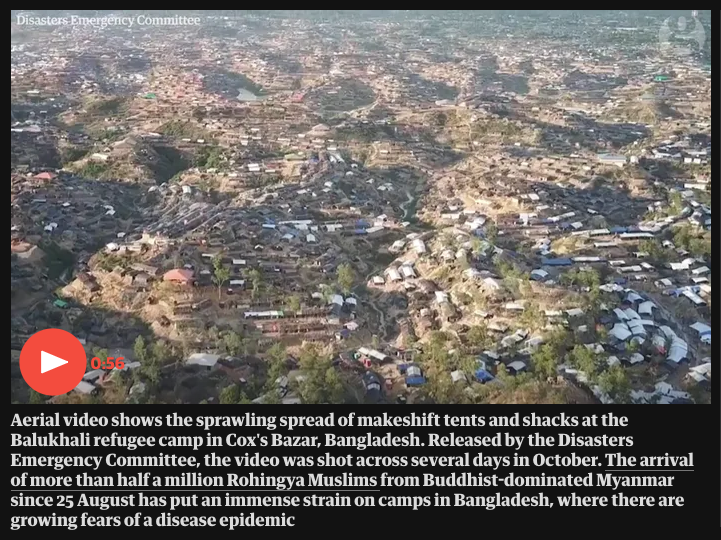
Fig. 4 Drone footage of displaced persons camps in Cox’s Bazar, Bangladesh recorded by the Disasters Emergency Committee was shared widely in the media | Credit: The Guardian
Aerial assessment can be used for more advanced impact analysis that would otherwise be difficult to conduct for reasons such as size of the affected area or access constraints for ground-based methods. An objective of such analysis might be to determine the extent of a flood or understand the percentages of structures destroyed by a cyclone in different towns.
An example of impact analysis is from July 2018 when a landslide struck hard-to-reach villages in a remote and impoverished area of Panjshir province, Afghanistan. Due to the logistic challenges of reaching the affected area, World Food Program (WFP) and the Afghanistan National Disaster Management Authority (ANDMA) requested iMMAP to use satellite imagery to assess the situation. iMMAP was able to use panchromatic satellite images from before and after the landslide to estimate the number of houses destroyed. Their analysis resulted in a number much different from initial, anecdotal reports but which was very close to the actual number confirmed after responders were able to assess the site in person.
Another example of impact analysis is from March 2019 when Cyclone Idai swept through Mozambique causing extensive damage with high speed winds and heavy rains. The IFRC, through a partnership with Airbus as well as coordination with other responding agencies, was able to mobilize helicopters and fixed wing planes for visual observations to follow up an analysis by the United Nations Operational Satellite Applications Programme (UNOSAT) and the United Nations Institute for Training and Research (UNITAR) detecting flooding extent with infrared satellite imagery. Numerous flights over 6 days were used to cover the large swathe of land that had been affected by the storm. A grid system was used to organize the coverage and mobile data collection forms filled out on smartphones were used to collect the data.
Impact analysis can extend to monitoring of slow onset and protracted disasters. Shifts in shelter and settlement dynamics are one example of data that can often be measured with aerial assessment. For example, REACH has used satellite-detected agricultural activity as a proxy for insecurity. Through observations of how crop production diminished or disappeared over time in the Lake Chad adjacent regions of Nigeria they could work to understand conflict in the area.
Aerial assessment can also be used for critical incident identification. This could be related to search and rescue activities to find people with emergency needs. It could also be recording the location of points of interest; for example, affected transportation infrastructure such as destroyed bridges.
Aerial assessment can be useful for inspection of unsafe or difficult to access locations. Drones have been used to inspect things like the underside of bridges and tops of wind turbines. They can be used to examine damage to buildings after an earthquake or industrial accident to help determine if it’s safe for responders to enter on foot. For example, after an explosion in a field the German Red Cross used a drone to help determine if the cause was old WWII ordinance and if there were risks for the responding police and fire department personnel. The drone let them check for a sinkhole or old mining path without potentially endangering the first responders.
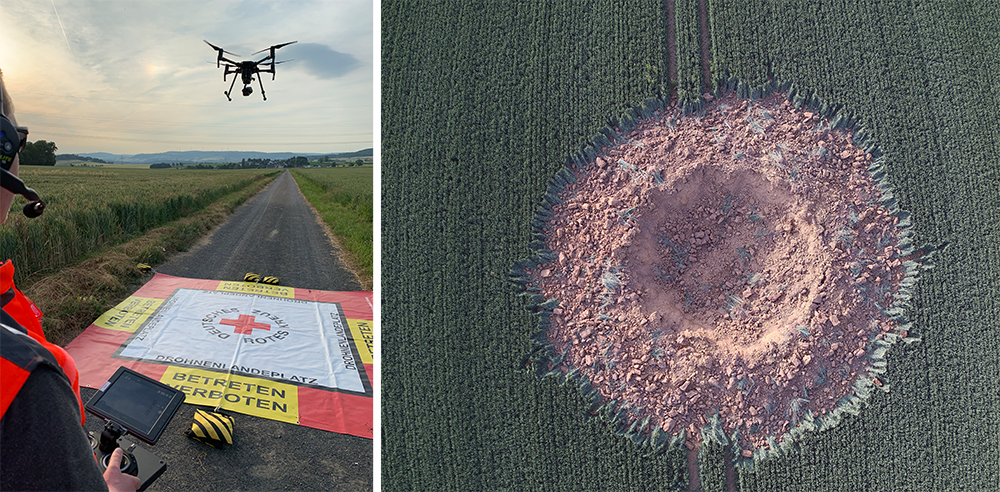
Fig. 5 German Red Cross investigation for Police of a self explosion of a 250 kg. WWII aircraft bomb in Ahlbach, Germany | Credit: Kai Brunner, German Red Cross - Kreisverband Limburg e.V., 2019
There are a few examples of aerial assessment being used for advanced analysis for program implementation. For example, in Cox’s Bazar, Bangladesh the drone-collected aerial imagery of the displaced persons camps was used to produce a digital elevation model and 1-meter contours. Details on the elevation and slope of land throughout the camps was useful for a range of purposes including: identifying locations for infrastructure like footpaths, communal shelters, and latrines; and prioritizing areas at high-risk of landslides or flooding for mitigation activities.