Changes to MapSwipe for a changing world
American Red Cross is excited to support a new MapSwipe mission type available in the v2.1.8 release.
Red Cross ❤️ OSM
Understanding places and the “where?” of things is vitally important for successful humanitarian programs and disaster response. It is important for getting from point A to point B as well as for coordination, understanding needs, tracking impact, identifying gaps, and a multitude of other concerns.
OpenStreetMap (OSM) is a global source of open geographic data that can be updated by people with whatever features and details are important to them. It takes a diverse community of mappers and a variety of tools to keep OSM an accessible source for up-to-date details on where people live and the systems that support them. Since 2014 the American Red Cross has supported Missing Maps, a collaborative humanitarian project that aims to grow a global community of mappers.
The original MapSwipe
MapSwipe is an open-source mobile app to make mapping around the world more coordinated and efficient. In the original MapSwipe ‘build area’ mission type, volunteers swipe through satellite images and tap an imagery tile once when they’ve located particular features such as buildings. This crowdsources the prioritization of areas. Mappers can be directed to areas flagged in a MapSwipe mission as having features of interest; they can spend less time panning across forest, desert, or other areas without the features. This is most useful for places that have never been previously mapped.
What else can we MapSwipe?
As humanitarians expand the ways they use geospatial data to inform their actions, they may require different, more detailed, and more accurate data. A simple base map for knowing where neighborhoods are in relation to one another requires less data than what is needed to predict the number of families impacted by a flood. Confirming that OSM data is appropriate for new types of maps and analyses is especially vital as time passes and environments change, for example with buildings constructed or torn down.
American Red Cross supported the MapSwipe team, through HeiGIT, to launch a footprint review mission type in January 2022. The new mission type is part of a quality assurance process. It enables users to review the accuracy of individual features previously traced into OSM using the most-recent available satellite imagery.
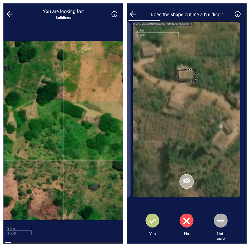
The original build area mission type (left) and the new footprint review mission (right).
The world changes and an area mapped last year might not still match OSM. The analytic results of the footprint review missions will help identify areas that need to be revisited by mappers due to changes in the built landscape. We plan to use the results to help determine the quality of building data in advance of it being used in forecast-based action, disaster risk planning, and other humanitarian activities of the global Red Cross Red Crescent network.
What’s next with MapSwipe
A key complement to understanding the accuracy of features existing in OSM, will be understanding if there are features missing from OSM. American Red Cross is already thinking about how a “completeness” mission type could complement the footprint review. Additionally, the Mapswipe developers have explored missions for comparing before and after images to detect disaster damages. What other data could MapSwipe help crowdsource?
Join in!
Download the MapSwipe app for Android or iOS and tell us what you think. Look for a mission with “OSM building validation” in the title to check out the new mission type. Please click the green “Tutorial” button from the mission page and learn about contributing before starting to map.
Follow @mapswipe on Twitter.
The MapSwipe maintainers accept financial contributions via Open Collective if you want to be part of the support that keeps the app running, maintained, and free of bugs.
If you code, check out the project on GitHub and see if there are any issues you can tackle. Email info@mapswipe.org if you would like to be added to the Slack workspace for the MapSwipe community.